
Press release: Adur tidal walls scheme harnesses the unique power of the Giken

The Environment Agency’s Adur tidal walls scheme in Shoreham-by-Sea is making great strides as it nears the final stages of construction with completion expected by the end of the year.

A major component to making good progress has been the use of the Giken press piling train to drive in the steel piles. This is a Giken silent piling unit, power pack, and crane mounted onto the piles (a ‘reaction stand’), using the installed piles as tracks – like a train. The Giken piler drives piles silently by pressing them into the ground. This is located at the front of the ‘train’ pressing piles in at the front. The whole train walks along, following the Giken silent piler to install piles in a linear fashion.

This equipment has proved to be key to working in the tight spaces between the Shoreham houseboats and the houses landside of the path, driving in the steel piles to form the wall’s core support.

The planning process needed to be carefully managed to ensure that stakeholder agreements were completed on time because of the specialist Giken press piling train required to install the sheet piles. This needed to be booked 6 months in advance as there are only a few in the world. Scheme contract partners Team Van Oord developed a stakeholder engagement programme to set out the process to obtain the agreements and the roles of project team organisations at each stage.

Following completion of sheet piling in the W5 reach*, the Giken train will be decommissioned on Thursday 2 August. The W5 reach is scheduled for reopening this autumn.

*The 7.2 kilometre long defence is split into 10 sections labelled as E for east or W for west of the river, ie E1, E2, E3, W1, W2, W3, W4, W5, W6, W7.

An Environment Agency spokesperson said:

We would like to thank everyone in Shoreham-by-Sea for their continued patience and support. More than two-thirds of the Shoreham Adur tidal walls flood defence scheme has now been completed. Having started construction in October 2016 we expect to finish by the end of this year.

A Team Van Oord spokesperson said:

In the W5 reach we have had to install some 1,176 sheet piles – each one 11 metres long. The work was complicated by being close to 40 houseboats along a stretch of 700m. However, we made sure to consult with stakeholders and houseboat owners keeping them informed on developments.

Thanks to their cooperation, we were able to continue the pile driving works in this reach without closing a larger area to the public.

Further information about the scheme is available on GOV.UK.

In addition, there is a dedicated visitor centre for the project, located in the Beach Green car park in Shoreham, and open from midday to 5pm Monday to Friday.

Contact details: email shorehamwestbank@environment-agency.gov.uk or write to:

SSD Enquiries

Environment Agency

Guildbourne House

Chatsworth Road

Worthing

BN11 1LD

For general information on how to prepare for flooding and the latest flood warnings in force please visit our floodline page or ring Floodline on 0345 9881188.

Notes to editors

The Shoreham Adur tidal walls scheme, made up of raised walls and embankments along the River Adur, is being constructed by the Environment Agency. Once complete, it will reduce the tidal flood risk to thousands of homes and commercial properties in the area, as well as protecting important local infrastructure such as roads, railway lines and Shoreham Airport. It is part of the Environment Agency’s 6-year plan to reduce the risk of flooding to at least 300,000 homes by 2020/21.

Adur tidal walls scheme in numbers

  • 7.2km of defences
  • 2,527 properties protected
  • 2.5km of steel sheet piling
  • 3km of flood embankment
  • 1km of concrete walls
  • ½km of flood glass
  • ½km of rock revetment
  • 2,316 lizards and slow worms relocated
  • 14,000m2 saltmarsh habitat to be created

Other key points of the scheme

The scheme will reduce the risk of flooding to over 2,300 homes and 169 commercial properties.
Consultation events in 2014 and 2015 provided public feedback on the designs now incorporated into the detailed designs.

The scheme boundary includes the nationally designated Adur Estuary Site of Special Scientific Interest (SSSI) and a RSPB reserve. These areas have over-wintering bird populations and significant areas of saltmarsh and mudflat. Saltmarsh and mudflat are priority habitats that have been identified as requiring conservation action under the Natural Environment and Rural Communities Act (2006).

The Environment Agency is aiming to minimise loss of saltmarsh habitat by moving the embankment next to the airport further back from its current position to create new saltmarsh habitat.

Link: Press release: Adur tidal walls scheme harnesses the unique power of the Giken
Source: Environment Agency
Press release: Manston Airport application accepted for examination

Today, Tuesday 14 August, The Planning Inspectorate has announced that the application for the upgrade and reopening Manston Airport has been accepted by the Secretary of State for Housing Communities and Local Government for examination.

The application for the proposed project was submitted on 17 July 2018 and the decision has been made within of the 28 day statutory deadline.

The application is for the upgrade and reopening of Manston Airport primarily as a cargo airport, with some passenger services, with a capacity of at least 12,000 air cargo movements per year.

In accordance with the Planning Act 2008 (as amended by the Localism Act 2011) , when considering whether or not to accept an application for examination, the Secretary of State has regard to the application documents submitted, any adequacy of consultation representations received from local authorities, and the extent to which the developer has had regard to any guidance issued. Other matters relating to the application will be considered by the Examining Authority during the examination and interested parties will have an opportunity take part in that process and give their views if they wish.

It is now for the applicant, RiverOak Strategic Partners Ltd, to publicise the fact that its application has been accepted for examination and invite people who are interested in the proposal to register with the Planning Inspectorate as an interested party by making a relevant representation.

Once the period for registering as an interested party has opened, people will easily be able to register online with the Planning Inspectorate by visiting the project’s page and completing the online ‘Registration and Relevant Representation form’. Alternatively, those without internet access may call the Planning Inspectorate helpline: 0303 444 5000 for a printed registration form.

Sarah Richards, Chief Executive, Planning Inspectorate said. “After careful consideration we have decided on behalf of the Secretary of State that the application submitted by RiverOak Strategic Partners Ltd met the required tests set out in the legislation to be accepted for examination”.

“The decision has been made within the statutory deadline. It demonstrates our ability to deliver a predictable, fair and efficient examination process that provides certainty for everyone involved.”

“The applicant must now decide and publicise when members of the public can play a part in the examination process by registering with the Planning Inspectorate as an interested party to give their views.”

Interested parties in an application can:

  • Say what they agree or disagree with in the application and why;
  • Comment on what other people have said in their representations;
  • Attend a Preliminary Meeting and say how they think the application should be examined;
  • Request that an open floor hearing is held; and
  • Attend and request to speak at open floor or issue-specific hearings should one be held.

The Planning Inspectorate’s Advice Note 8.3, ‘How to register and become an interested party in an application’ is available on the Inspectorate’s website or a copy can be requested by calling 0303 444 5000.

Ends

Journalists wanting further information should contact the Planning Inspectorate Press Office, on: 0303 444 5004 or 0303 444 5005 or email: pressoffice@pins.gsi.gov.uk.

Notes to editors:

  • The acceptance to proceed to examination decision and a copy of the application can be viewed at the Manston Airport project page on the Planning Inspectorate’s website.
  • The Planning Inspectorate, National Infrastructure Programme of Projects details the proposals which are anticipated to be submitted to the Planning Inspectorate as applications in the coming months.
    Copies of the application documents can be viewed online on the project page.

The process in a snapshot

There are six key stages within the process. The summary below provides examples of when and how people have an opportunity to provide evidence to the Planning Inspectorate.
Pre-application

Key activities:

  • Project development / developer’s pre-application consultation and publicity.
  • Environmental impact assessment preparation and scoping, where required.

Public involvement:

  • Have their say on the proposal to the developer through their pre application consultation
    Acceptance by the Planning Inspectorate on behalf of the Secretary of State

Key activities:

  • The Secretary of State has 28 days from the day after receipt to decide whether or not an application should be accepted for examination

Public involvement:

  • Details will be posted at the Planning Inspectorate’s website on how to register as an interested party – once an application has been accepted for examination and publicised by the developer.
  • Opportunity to legally challenge a decision not to accept an application.

Pre-examination

Key activities:

  • Single Inspector or a Panel of three or more Inspectors appointed.
  • Preliminary Meeting called and held.
  • Procedure and timetable set for examination.

Public involvement:

  • Register to say what you agree or disagree with in the application
  • Submit your representation
  • View application documents submitted by the developer on the Planning Inspectorate website
  • Attend the Preliminary Meeting
  • Say how the examination should be conducted.

Examination

Key activities:

  • A maximum of six months to carry out the examination

Public involvement:

  • Submit more detailed comments in writing
  • Comment on what other people have said
  • Request and attend an open-floor hearing
  • If being held, request to speak at open-floor and / or issue specific hearing(s)
  • Comment on the local authority’s Local Impact Report – detailing the impact of the scheme on the local area.

Decision

Key activities:

  • A maximum of three months for Planning Inspectorate to issue a recommendation to the relevant Secretary of State, with a statement of reasons.
  • The relevant Secretary of State then has a further three months from receiving the recommendation in which to issue the decision.

Post decision

Key activities:

  • Six weeks for any legal challenge.

Public involvement:

Opportunity to challenge.

Link: Press release: Manston Airport application accepted for examination
Source: Gov Press Releases

Press release: UK House Price Index for June 2018

The June data shows:

  • on average, house prices have risen by 0.4% since May 2018
  • an annual price rise of 3%, which makes the average property in the UK valued at £228,384

England

In England, the June data shows on average, house prices have risen by 0.3% since May 201. The annual price rise of 2.7% takes the average property value to £245,076.

The regional data for England indicates that:

  • West Midlands experienced the greatest monthly price rise, up by 1.9%
  • the North East saw the most significant monthly price fall, down by 1.9%
  • London saw the lowest annual price increase, down by 0.7%

Price change by region for England

Region Average price June 2018 Monthly change % since May 2018
East Midlands £187,553 -0.5
East of England £292,632 1.0
London £476,752 -0.6
North East £127,271 -1.9
North West £159,801 0.5
South East £325,107 0.6
South West £252,558 -0.5
West Midlands £196,015 1.9
Yorkshire and the Humber £160,727 0.9

Repossession sales by volume for England

The lowest number of repossession sales in April 2018 was in the East of England.

The highest number of repossession sales in April 2018 was in the North West.

Repossession sales April 2018
East Midlands 45
East of England 9
London 37
North East 64
North West 120
South East 45
South West 42
West Midlands 40
Yorkshire and the Humber 68
England 470

Average price by property type for England

Property type June 2018 June 2017 Difference %
Detached £367,947 £357,220 3.0
Semi-detached £229,360 £220,112 4.2
Terraced £198,836 £192,410 3.3
Flat/maisonette £226,638 £227,646 -0.4
All £245,076 £238,595 2.7

Funding and buyer status for England

Transaction type Average price June 2018 Annual price change % since June 2017 Monthly price change % since May 2018
Cash £230,065 2.4 0.0
Mortgage £252,647 2.9 0.4
First-time buyer £206,005 2.5 0.5
Former owner occupier £277,690 2.9 0.1

Building status for England

Building status* Average price April 2018 Annual price change % since April 2017 Monthly price change % since March 2018
New build £310,029 7.8 3.9
Existing resold property £238,785 3.2 0.9

*Figures for the two most recent months are not being published because there are not enough new build transactions to give a meaningful result.

Sales volumes for England

The most up-to-date HM Land Registry sales figures available for England show:

  • the number of completed house sales in England fell by 19.3 per cent to 50,308 compared with 62,318 in April 2017
Month Sales 2018 Sales 2017 Difference %
March 62,237 74,386 -16.3
April 50,308 62,318 -19.3

London

London shows, on average, house prices have fallen by 0.6% since May 2018. An annual price fall of 0.7% takes the average property value to £476,752.

Average price by property type for London

Property type June 2018 June 2017 Difference %
Detached £909,473 £890,539 2.1
Semi-detached £588,852 £569,116 3.5
Terraced £496,983 £490,877 1.2
Flat/maisonette £416,101 £428,001 -2.8
All £476,752 £480,152 -0.7

Funding and buyer status for London

Transaction type Average price June 2018 Annual price change % since June 2017 Monthly price change % since May 2018
Cash £495,907 -1.7 -1.2
Mortgage £470,879 -0.4 -0.4
First-time buyer £417,193 -1.1 -0.6
Former owner occupier £537,783 -0.2 -0.7

Building status for London

Building status* Average price April 2018 Annual price change % since April 2017 Monthly price change % since March 2018
New build £512,049 3.9 4.3
Existing resold property £477,123 -0.3 1.3

*Figures for the two most recent months are not being published because there are not enough new build transactions to give a meaningful result.

Sales volumes for London

The most up-to-date HM Land Registry sales figures available for London show;

  • the number of completed house sales in April 2018 fell by 26% to 5,272 compared with 7,120 in April 2017
Month Sales 2018 Sales 2017 Difference %
March 6,685 8,659 -22.8
April 5,272 7,120 -26.0

Wales

Wales shows, on average, house prices have risen by 1.7% since May 2018. An annual price rise of 4.3% takes the average property value to £156,886.

Average price by property type for Wales

Property type June 2018 June 2017 Difference %
Detached £234,339 £225,439 3.9
Semi-detached £151,991 £143,947 5.6
Terraced £121,586 £116,907 4.0
Flat/maisonette £114,043 £110,994 2.7
All £156,886 £150,394 4.3

Funding and buyer status for Wales

Transaction type Average price June 2018 Annual price change % since June 2017 Monthly price change % since May 2018
Cash £152,601 4.0 1.8
Mortgage £159,428 4.5 1.6
First-time buyer £135,691 4.2 1.9
Former owner occupier £181,538 4.4 1.4

Building status for Wales

Building status* Average price April 2018 Annual price change % since April 2017 Monthly price change % since March 2018
New build £210,429 7.9 2.1
Existing resold property £150,819 2.5 -0.3

*Figures for the two most recent months are not being published because there are not enough new build transactions to give a meaningful result.

Sales volumes for Wales

The most up-to-date HM Land Registry sales figures available for Wales show:

  • the number of completed house sales in April 2018 fell by 13.9% to 3,005 compared with 3,490 in April 2017
  • there were 54 repossession sales in April 2018
Month Sales 2018 Sales 2017 Difference %
March 3,547 3,909 -9.3
April 3,005 3,490 -13.9

Access the full UK HPI

UK house prices rose by 3.0% in the year to June 2018, down from 3.5% in the year to May 2018. This is the lowest UK annual rate since August 2013 when it was also 3.0%.

The UK Property Transaction Statistics for June 2018 showed that on a seasonally adjusted basis, the number of transactions on residential properties with a value of £40,000 or greater was 96,340. This is 5.7% lower compared to a year ago. Between May and June 2018, transactions decreased by 3.0%.

West Midlands was the fastest growing region with an annual growth rate of 5.8%, up from 5.0% in the previous month. London was the slowest growing region, falling by 0.7% in the year to June 2018, down from negative 0.2% in the previous month.

See the economic statement.

Notes to editors

  1. The UK House Price Index (HPI) is published on the second or third Wednesday of each month with Northern Ireland figures updated quarterly. The July 2018 UK HPI will be published at 9.30am on Wednesday 19 September 2018. See calendar of release dates.
  2. We have made some changes to improve the accuracy of the UK HPI. We are not publishing average price and percentage change for new builds and existing resold property as done previously because there are not currently enough new build transactions to provide a reliable result. This means that in this month’s UK HPI reports, new builds and existing resold property are reported in line with the sales volumes currently available.
  3. The UK HPI revision period has been extended to 13 months, following a review of the revision policy (see calculating the UK HPI section 4.4). This ensures the data used is more comprehensive.
  4. Sales volume data is also available by property status (new build and existing property) and funding status (cash and mortgage) in our downloadable data tables. Transactions involving the creation of a new register, such as new builds, are more complex and require more time to process. Read revisions to the UK HPI data.
  5. Revision tables have been introduced for England and Wales within the downloadable data. Tables will be available in CSV format. See about the UK HPI for more information.
  6. Data for the UK HPI is provided by HM Land Registry, Registers of Scotland, Land & Property Services/Northern Ireland Statistics and Research Agency and the Valuation Office Agency.
  7. The UK HPI is calculated by the Office for National Statistics (ONS) andLand & Property Services/Northern Ireland Statistics and Research Agency. It applies a hedonic regression model that uses the various sources of data on property price, in particular, HM Land Registry’s Price Paid Dataset, and attributes to produce estimates of the change in house prices each month. Find out more about the methodology used from the ONS and Northern Ireland Statistics & Research Agency.
  8. The UK Property Transaction statisticsare taken from HM Revenue and Customs (HMRC) monthly estimates of the number of residential and non-residential property transactions in the UK and its constituent countries. The number of property transactions in the UK is highly seasonal, with more activity in the summer months and less in the winter. This regular annual pattern can sometimes mask the underlying movements and trends in the data series so HMRC also presents the UK aggregate transaction figures on a seasonally adjusted basis. Adjustments are made for both the time of year and the construction of the calendar, including corrections for the position of Easter and the number of trading days in a particular month.
  9. UK HPI seasonally adjusted series are calculated at regional and national levels only. See data tables.
  10. The first estimate for new build average price (April 2016 report) was based on a small sample which can cause volatility. A three-month moving average has been applied to the latest estimate to remove some of this volatility.
  11. Work has been taking place since 2014 to develop a single, official HPI that reflects the final transaction price for sales of residential property in the UK. Using the geometric mean, it covers purchases at market value for owner-occupation and buy-to-let, excluding those purchases not at market value (such as re-mortgages), where the ‘price’ represents a valuation.
  12. Information on residential property transactions for England and Wales, collected as part of the official registration process, is provided by HM Land Registry for properties that are sold for full market value.
  13. The HM Land Registry dataset contains the sale price of the property, the date when the sale was completed, full address details, the type of property (detached, semi-detached, terraced or flat), if it is a newly built property or an established residential building and a variable to indicate if the property has been purchased as a financed transaction (using a mortgage) or as a non-financed transaction (cash purchase).
  14. Repossession sales data is based on the number of transactions lodged with HM Land Registry by lenders exercising their power of sale.
  15. For England, this is shown as volumes of repossession sales recorded by Government Office Region. For Wales, there is a headline figure for the number of repossession sales recorded in Wales.
  16. The data can be downloaded as a .csv file. Repossession sales data prior to April 2016 is not available. Find out more information about repossession sales.
  17. Background tables of the raw and cleansed aggregated data, in Excel and CSV formats, are also published monthly although Northern Ireland is on a quarterly basis. They are available for free use and re-use under the Open Government Licence.
  18. HM Land Registry’s mission is to guarantee and protect property rights in England and Wales.
  19. HM Land Registry is a government department created in 1862. It operates as an executive agency and a trading fund and its running costs are covered by the fees paid by the users of its services. Its ambition is to become the world’s leading land registry for speed, simplicity and an open approach to data.
  20. HM Land Registry safeguards land and property ownership worth in excess of £4 trillion, including around £1 trillion of mortgages. The Land Register contains more than 25 million titles showing evidence of ownership for some 85% of the land mass of England and Wales.
  21. For further information about HM Land Registry visit www.gov.uk/land-registry
  22. Follow us on Twitter @HMLandRegistry, our blog, LinkedIn and Facebook

Contact

Press Office

Trafalgar House
1 Bedford Park
Croydon
CR0 2AQ

Link: Press release: UK House Price Index for June 2018
Source: Gov Press Releases

Press release: Government launch call for evidence to be geospatial world leader

  • Geospatial call for evidence launched today, focussing on innovation, enhancing geospatial assets and driving investment.
  • Geospatial Commission established to help unlock value of the sector, valued up to £11 billion per year.
  • This call for evidence is a pivotal moment to help set UK’s future geospatial vision. Government urges private and public sector to respond.

The government is urging the UK’s geospatial sector and beyond to take part and share views on their future vision, as part of its call for evidence launched today.

The creation of the Geospatial Commission was announced in November 2017, to maximise the value of data linked to location, which could generate £11 billion a year.

By using location data, geospatial technology is transforming services across the private and public sectors to contribute to the #SmarterGov Government campaign, which helps deliver wider economic growth and productivity. From emergency services, transport planning, and 5G networks, to housing, smarter cities and drones – the UK’s geospatial infrastructure has the potential to revolutionise the UK’s economy.

The Minister for the Cabinet Office and Chancellor of the Duchy of Lancaster, David Lidington, said,

The data revolution is changing the way we see the world and the way we live our lives – and this government is determined to make the most of the opportunities it presents.

The launch of today’s call for evidence is another key milestone in the Geospatial Commission’s exciting journey. We want to hear how the use of geospatial data can support economic growth and productivity across the United Kingdom, while transforming how public services are delivered.

This is crucial in helping to inform the UK’s first ever Geospatial Strategy, which the Government will launch next year.

Call for evidence document

The call for evidence document is linked to below:


Geospatial Commission: call for evidence 2018
(PDF, 1.76MB, 40 pages)

Call for evidence questionnaire

The call for evidence questionnaire is linked to below in various formats:


Geospatial Commission response questionnaire (odt)
(ODT, 18.9KB)


Geospatial Commission response questionnaire (docx)
(MS Word Document, 30.3KB)


Geospatial Commission response questionnaire (pdf)
(PDF, 88.9KB, 9 pages)

Initial analysis

This document sets out the initial high-level analysis which contributed to the Government’s announcement of the creation of a Geospatial Commission in the 2017 Autumn Budget:


Initial Analysis of the Potential Geospatial Economic Opportunity
(PDF, 453KB, 18 pages)

Notes to editors

Geospatial Commission

The Geospatial Commission is an impartial expert committee within the Cabinet Office, supported by £40 million of new funding in each of the next two years, and will drive the move to use public and private sector geospatial data more productively. Research estimates that this could contribute up to £11 billion of extra value for the economy every year. The Geospatial Commission is due to publish its first annual plan next Spring.

Further details on the Geospatial Commission can be found in this press release: Chancellor to unlock hidden value of government data

Partner bodies

The Geospatial Commission has 6 partner bodies. These are:

  • British Geological Survey
  • Coal Authority
  • HM Land Registry
  • Ordnance Survey
  • UK Hydrographic Office
  • Valuation Office Agency

Link: Press release: Government launch call for evidence to be geospatial world leader
Source: Gov Press Releases

Press release: Litter Innovation Fund: further grants available for innovative community projects

Over £300,000 is now available for community projects that get tough on litter, Environment Minister Thérèse Coffey has announced today (15 August 2018).

The first round saw a number of councils, charities, businesses, and public projects awarded almost £125,000 to take innovative steps to tackle littering in their communities. The successful projects included measures to tackle littering by football fans, and working with hauliers and business owners to reduce roadside litter.

As part of the Fund, Defra is also preparing to launch a ‘digital innovation challenge’ to help find innovative digital and technological solutions to local litter challenges. We have already seen mobile apps like LoveCleanStreets, “Littergram” or “Find it Fix It Love It” showcase digital and technological solutions to help people report litter problems and see a speedy resolution.

The funding builds on the Government’s wider Litter Strategy for England, as well as the recent launch of the 25 Year Environment Plan setting out how Government will protect and enhance our natural environment. 10% of the fund is entirely dedicated to preventing marine litter.

Environment Minister Thérèse Coffey said:

This Government is tough on tackling litter which if left unchecked makes our towns and cities less pleasant places, poisons our wildlife, and blights our countryside.

That is why we are providing grants of up to £10,000 for communities to come up with creative solutions to tackle litter in their local area and I encourage local groups to apply.

It is only through government and communities working together that we will affect the long-term behavioural change that is needed to tackle this scourge, and leave the environment in a better state than we inherited it.

Communities Minister Rishi Sunak said:

We are determined to make our cities, towns and countryside greener, cleaner and tidier environments for all.

Brilliant ideas to make that happen were realised with the first round of funding. Now, we’re looking for people to come forward with inventive and impactful projects to build on that and our wider strategy to substantially reduce litter.

Keep Britain Tidy Chief Executive Allison Ogden-Newton said:

Innovation is a vital part of turning the tide on litter. We need to find new ways to change the behaviour of those who think it is OK to drop their rubbish on the ground and new solutions that make it easier for people to do the right thing.

It is fantastic to see the Government supporting innovation through this scheme, which is helping organisations and communities develop exciting new ideas and approaches, and at Keep Britain Tidy we are delighted to be receiving funds to enable us to test new behavioural interventions through our award-winning Centre for Social Innovation.

Keeping the country’s streets clean cost local Government almost £700 million last year. Much of this is avoidable litter, and money that could be better spent in the community. Despite this, a worrying 1 in 5 people admit to dropping litter, with a recent study showing 1 in 4 people admit to ‘careful littering’ such as leaving drinks cans or coffee cups on window ledges.

Government has recently announced a range of new measures to get tough on litter including almost doubling on-the-spot fines for litter louts, and new penalties for littering from vehicles, making the keeper of the vehicle responsible even if it isn’t possible to identify precisely who threw the litter.

The UK continues to be a global leader in tackling waste, recently announcing a world-leading ban on microbeads, and proposals to extend the 5p plastic bag charge. Government has also recently announced an intention to ban the sale of plastic straws, stirrers and cotton buds, plans for a deposit return scheme to increase recycling rates of drinks bottles and cans, and launched a call for evidence on using the tax system or charges to address single-use plastic waste.

The Litter Innovation Fund application window closes 5 October.

Background

  • The Litter Innovation Fund was set up as part of the Government’s Litter Strategy for England which was launched in April 2017 and is administered by the sustainability not-for-profit WRAP. A total of £450,000 is available for funding to local projects.
  • The funding is evenly provided by the Department for Environment, Food & Rural Affairs and the Ministry for Housing, Communities and Local Government and funding awarded is limited to a maximum of £10,000 per project. Projects must also secure match-funding.
  • The cost of £682m in 2016/17 for street cleaning is from Official local Government returns to DCLG.
  • Further information on the Litter Innovation Fund is available on the WRAP website.
  • Research on one in five admitting to having dropped litter in the past is from Keep Britain Tidy – Litter Droppers Segmentation research (2010).
  • Research on 27% of people admitting to ‘careful littering’ is from a poll by YouGov for Keep Britain Tidy (2018).
  • Results from the first round of projects will be published in due course.

Link: Press release: Litter Innovation Fund: further grants available for innovative community projects
Source: Gov Press Releases

Press release: UK Visas & Immigration Freetown Visa Application Centre moves to a New Location

On 30 July 2018, UK Visas and Immigration’s Visa Application Centre (VAC) in Freetown moved to a new premises. Customers making a new application should attend their appointment at the new VAC. Customers who have still to collect their application will now need to report to the new address.

UK visa customers will continue to complete their applications and pay their visa fee online at Visa4UK/ Access UK in exactly the same way as before, and choose an appointment at the TLS Contact VAC in Freetown.

The Visa Application Centre in Freetown will be open every week day between 08:30hrs – 14:30hrs. Customers will be able to make appointments to submit visa applications in Freetown between 08:30hrs and 14:30hrs Monday to Friday.

As before, applications made in Freetown will be processed in line with UKVI’s global customer service standards. All UK visa applications will continue to be decided by UK Visas and Immigration staff in a fair and objective process. Staff at the Visa Application Centre have no influence at all over the outcome of any visa application.

New Visa Application Centre Address

UK Visa Application Centre
TLS Contact
West African Sunshine Building
Gouji Property Development
Building No: 5
7 Lumley Beach Road
Aberdeen
Freetown

Link: Press release: UK Visas & Immigration Freetown Visa Application Centre moves to a New Location
Source: Gov Press Releases

Press release: Native crayfish make a comeback in Lincolnshire

A threatened species of crayfish is making a comeback in Lincolnshire thanks to efforts by the Environment Agency and local conservation groups.

Last July, 600 white-clawed crayfish were moved from locations in the River Witham – where they’re at risk of being wiped out by invasive signal crayfish – to new remote locations including a chalk stream in the Lincolnshire Wolds.

Now, surveys show the transfer – the first in the county – has been successful, and the crayfish have started to breed.

Native white-clawed crayfish have been in decline since non-native American signal crayfish escaped into UK waters in the 1970s. These larger, invasive crayfish outcompete native species for food and habitat and carry a disease fatal to the UK species.

But working with partners such as the Lincolnshire Chalk Streams Project (LCSP) and the Lincolnshire Wildlife Trust, the Environment Agency is seeking to secure their future by relocating them to areas free of the invaders in a scheme known as the ‘ark project.’

Richard Chadd, senior environmental monitoring officer with the Environment Agency said:

These crayfish are a vital part of our ecology, so preserving them is yet another example of how we’re protecting our environment for the future.

Having personally worked on this project – physically picking up these crayfish, measuring them, checking their health and relocating them to their new homes – I’m thrilled that our efforts at protecting them have been so successful.

Previously the crayfish were only present in two locations in the county, so we’ve potentially doubled their habitat in the space of a year – and Lincolnshire’s rare, protected chalk streams are the perfect home. They’re remote, clean, and the water is high in calcium, which helps crayfish form strong exoskeletons and makes them more robust.

Ruth Craig, Lincolnshire Chalk Streams Project Officer, said:

The Lincolnshire Chalk Streams Project jumped at the chance to support this EA-led initiative to establish native white-clawed crayfish sites in the chalk streams of the Lincolnshire Wolds.

We offered up some potential sites and once they were all assessed, we were excited to hear one of the chalk streams had scored as highly suitable.

We worked closely with local landowners to secure access and their long-term support in protecting the area from disturbance, and we will return to monitor the populations as needed. But the hard work doesn’t end here – we plan to continue identifying further possible locations, supporting the work of the EA.

White-clawed crayfish, named for the pale colour of the underside of their claws, are the country’s largest native freshwater crustaceans. Generally growing to 30 – 40mm in length, some can live up to 12 years and reach 120mm long from tip to tail.

Collectively, non-native invasive species cost the UK economy an estimated £1.7b every year.
Everyone can do their part to prevent the spread of invasive species and protect native ones by taking care to follow the biosecurity steps of thoroughly checking, cleaning and drying your clothes and equipment any time you’ve been in the water. You can get more information from the Non-native Species Secretariat.

Link: Press release: Native crayfish make a comeback in Lincolnshire
Source: Environment Agency

Press release: Happy dace for River Tyne fish survey

The Environment Agency joined forces with expert anglers for the second year running to carry out an important survey to assess the numbers of a highly prized fish in Northumberland.

Surveys for dace, the main species of coarse fish in the River Tyne, much valued by anglers, took place on the North Tyne tributary as part of a wider programme to monitor any impact of the revised releases of water from Kielder Reservoir.

Environment Agency specialists teamed up with 17 expert anglers from the Tyne Anglers Alliance and other fishing clubs – with anglers from as far afield as Yorkshire and the Scottish Borders making the trip – to fish around a dozen locations between Kielder and Watersmeet.

The aim was to both update and enhance our existing information on dace populations.
There were some great results – including a whopping 27lb catch at Wark and an 18lb bag from Redesmouth.

Good numbers of young dace

Environment Agency Fisheries Officer Niall Cook, who organised the survey, said:

After such a successful event last year we are now looking to run this annually so we can build up a detailed picture of where dace can be found in the North Tyne and also where perhaps they aren’t so abundant.

The survey this year was particularly successful in that it showed good numbers of young dace in the middle reaches of the North Tyne. This contrasted with the 2017 survey when almost all dace caught were older fish.

Angling was used in preference to other survey methods like electric fishing and netting because dace are highly mobile and difficult to catch, especially in wide rivers like the North Tyne.

The Environment Agency, Northumbrian Water and the hydropower operator, Innogy Renewables UK Ltd worked together in 2016 to make changes to the operating arrangements for the release of water from Kielder Reservoir.

An annual trial concluded in October 2017 and the changes are intended to maintain the future of water supply to the North East, better reflect the natural changes in river flows, provide increased flood storage in the reservoir and increase the generation of clean, renewable energy.

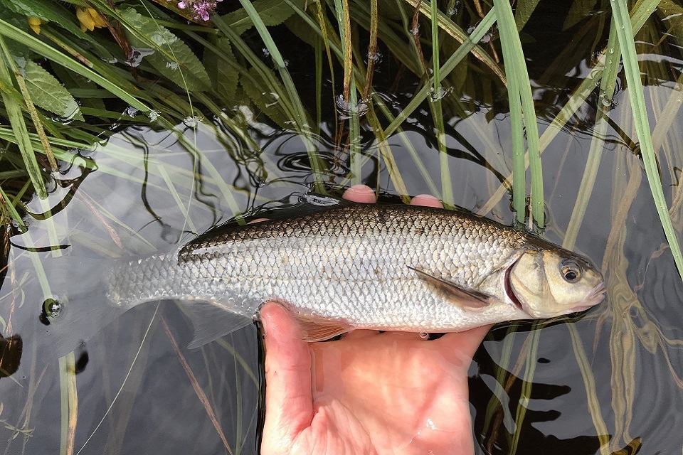
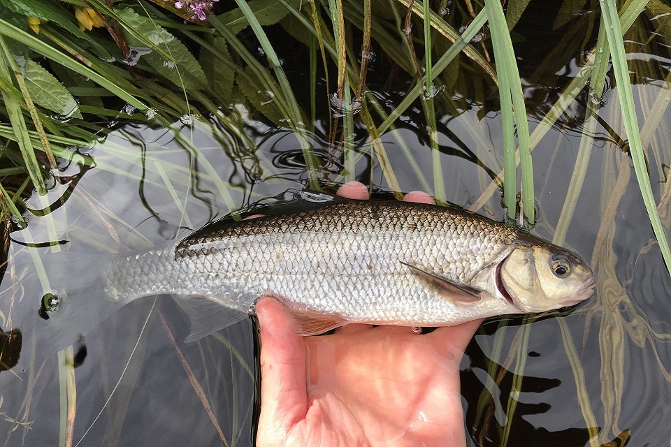
Image shows one of the dace caught in the survey

Surveys provide information

Hydrologist Rachel Merrix, who led on the trial for the Environment Agency, added:

Although the annual trial of the revised release regime ended last October we continue to monitor river flows and temperature to ensure that the environment is protected. Fish surveys such as this one provide us with additional information which increases our confidence that the revised releases are not having an adverse effect on native coarse fish.

We have had some feedback from both reservoir and river users on the impact of the releases but would encourage others to let us know if they have any concerns.

We continuously monitor river levels, flows and water temperatures at several locations in the Tyne catchment and all of this data is available on request.

Other activities to monitor the impact of the new Kielder release regime include temperature monitoring at 11 new sites, as well as electric fishing surveys for juvenile salmonoids and freshwater pearl mussel assessments.

For more information and updates on the trial visit the Kielder release website or email Kielder.reservoir@environment-agency.gov.uk with any queries or observations.


Link: Press release: Happy dace for River Tyne fish survey
Source: Environment Agency

The Local Government (Structural Changes) (General) (Amendment) Regulations 2018

Part 1 of the Local Government and Public Involvement in Health Act 2007 (“the 2007 Act”) provides for the establishment of a single tier of local government for areas in England. There is a single tier of local government for an area if there is either a county council and no district councils for that area, or a district council and no county council for that area (section 1(2) of the 2007 Act). The Secretary of State may by order implement (with or without modification) a proposal received for a single tier of local government (section 7 of the 2009 Act).

Link: The Local Government (Structural Changes) (General) (Amendment) Regulations 2018
Source: Legislation .gov.uk